Trail Walking La Tuilière - La Tuilière - Photo
 tracegps
tracegps

User

© OpenStreetMap contributors
Length
Length
9.4 km
Max alt
Max alt
834 m
Uphill gradient
Uphill gradient
276 m
Km-Effort
Km-Effort  
13 km
Min alt
Min alt
668 m
Downhill gradient
Downhill gradient
275 m
Boucle
Boucle
Yes
Creation date :
2014-12-10 00:00:00.0
Updated on :
2014-12-10 00:00:00.0

(0 Reviews)

Walking
Walking
1h30
Difficulty : Easy

Scan this QR Code to open this trail in the SityTrail application

FREE GPS app for hiking

Logo SityTrail SityTrail

IGN / Geographical institutes

Download SityTrail from the App Store Download SityTrail from Google Play

Logo SityTrail SityTrail World

The world is yours!

Download SityTrail from the App Store Download SityTrail from Google Play Download SityTrail on Huawei AppGallery

About

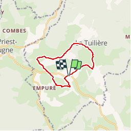
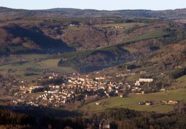
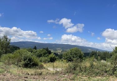
Trail Walking of 9.4 km to be discovered at Auvergne-Rhône-Alpes, Loire, La Tuilière. This trail is proposed by tracegps.

Description

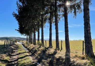
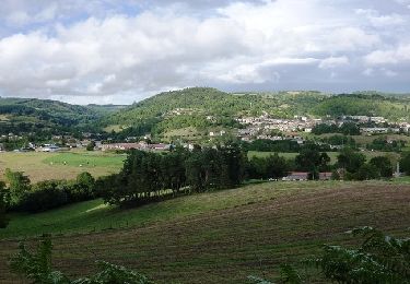
Rando sympa - très facile - bonne vue tout au long du parcours - 09kms500

Elevation profile

Positioning

Country:
France
Region :
Auvergne-Rhône-Alpes
Department/Province :
Loire
Municipality :
La Tuilière
Location:
Unknown
Start:(UTM)
561975 ; 5088227 (31T) N.

Trails nearby

Trail Walking Cherier - Les Moulins Chérier : entre Les Faux et Montloup - Photo
Walking
Jgar

Walking

Medium
Cherier, Auvergne-Rhône-Alpes, Loire, France
8.5 km | 10.9 km-effort
2h 30min
Yes
Trail Running La Tuilière - La Croix de l'Epinat (circuit N°14) - La Tuilière - Photo
Running
tracegps

Running

Difficult
La Tuilière, Auvergne-Rhône-Alpes, Loire, France
16 km | 22 km-effort
2h 15min
Yes
Trail Mountain bike La Tuilière - La Croix de l'Epinat (circuit N°14) - La Tuilière - Photo
Mountain bike
tracegps

Mountain bike

Medium
La Tuilière, Auvergne-Rhône-Alpes, Loire, France
16 km | 22 km-effort
1h 30min
Yes
Trail Walking La Tuilière - La Croix de l'Epinat (circuit N°14) - La Tuilière - Photo
Walking
tracegps

Walking

Difficult
La Tuilière, Auvergne-Rhône-Alpes, Loire, France
16 km | 22 km-effort
4h 15min
Yes
Trail Mountain bike Saint-Just-en-Chevalet - Espace VTT du Massif des Bois Noirs - Circuit N° 15 - Saint-Just-en-Chevalet - Photo
Mountain bike
tracegps

Mountain bike

Difficult
Saint-Just-en-Chevalet, Auvergne-Rhône-Alpes, Loire, France
32 km | 43 km-effort
3h 0min
Yes
Trail Mountain bike Saint-Just-en-Chevalet - La Bois Noir Oxygène  2011 / Parcours de 100 km / Saint Just en Chevalet - Photo
Mountain bike
tracegps

Mountain bike

Very difficult
Saint-Just-en-Chevalet, Auvergne-Rhône-Alpes, Loire, France
92 km | 128 km-effort
7h 0min
Yes
Trail Walking Saint-Just-en-Chevalet - St-Just-en-Chevalet : Arpheuille - Photo
Walking
Jgar

Walking

Very difficult
Saint-Just-en-Chevalet, Auvergne-Rhône-Alpes, Loire, France
12.9 km | 19.6 km-effort
4h 27min
Yes
Trail Walking Cherier - Randonnée sur le  Plateau de Cherrier - Photo
Walking
tracegps

Walking

Medium
Cherier, Auvergne-Rhône-Alpes, Loire, France
7.9 km | 10.1 km-effort
3h 0min
Yes
Trail Mountain bike Saint-Just-en-Chevalet - BNO 2011 46kms - Saint Just en Chevalet - Photo
Mountain bike
tracegps

Mountain bike

Difficult
Saint-Just-en-Chevalet, Auvergne-Rhône-Alpes, Loire, France
44 km | 61 km-effort
4h 0min
Yes


Close
My subscriptions